- Our Story
- Our Impact
-
Our Projects

Commercial

- Careers
 Enquire
 Call
Call
 chat
chat
 Search
Insights Brief - Integrated Townships and Cooler Settlements: What Planned Developments Reveal About Heat Sensitive Urban Planning.
By mrinal shrivastava – rmi, akhil singhal, tarun garg – rmi india foundation, aun abdullah – lodha
July 18, 2025As Indian cities grow denser, the rising intensity of urban heat islands (UHIs) is no longer just a climate phenomenon — it's a planning crisis. Heat waves are becoming deadlier, electricity demand is soaring due to rising cooling needs, and urban neighbourhoods, especially informal ones, are turning into thermal traps. In this context, a series of studies done in Palava Phase 1, Palava Phase 2, Thane and Delhi, offer critical lessons for how urban form, material choices, and planning tools can make or break thermal comfort in urban settings. The previous insights brief (Shrivastava, et al. 2025) explores UHI characteristics of a planned urban township (Palava Phase 2; see Lodha and RMI India Foundation (2023) for Phase 1) compared to an adjacent rural/peri-urban settlement (Khoni Pagadyacha Pada). It tried to establish the reversing trend of how high-density, yet rightly planned urbanisation can still lower UHI effect when compared to an organic peri-urban/rural settlement. This further established the need for exploration of control sites at various levels in terms of layout, functions, building design and materials.
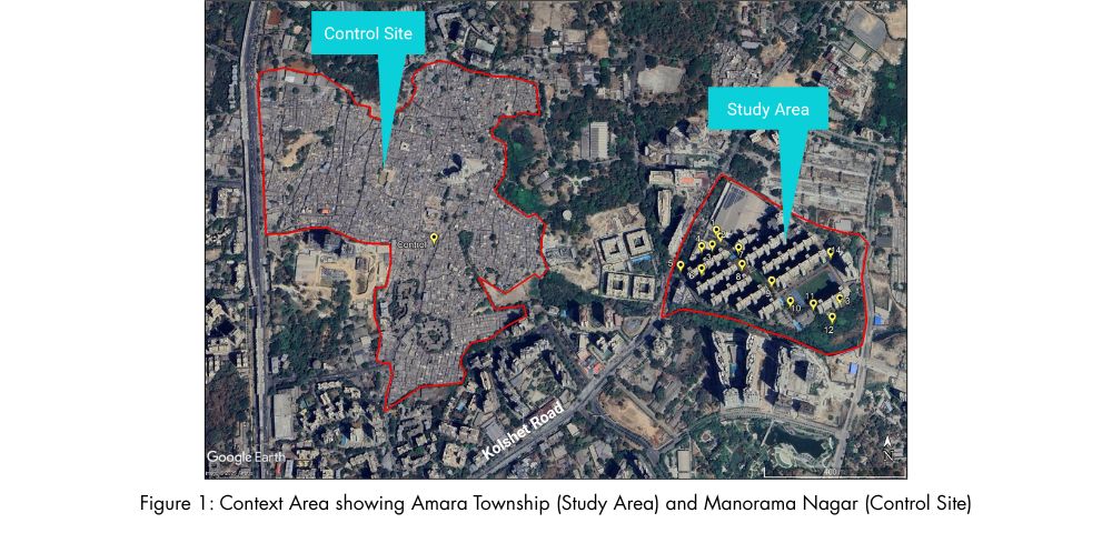
This insight brief – based on a recent urban heat study conducted in a planned urban township, Amara in Thane — compared against the adjacent urban informal settlement of Manorama Nagar — further strengthens and explores those lessons through the lens of planning-related drivers of heat and makes the case for embedding heat-sensitive principles into urban regulation, design and institutions. This study discusses the role of heat-sensitive principles at 3 spatial levels or realms: zoning, built-from, as well as walkways, building & materials. This offers structure for furthering discourse on heat-sensitive planning approaches.
Contrasting Urban Forms: Planned vs Organic Settlements
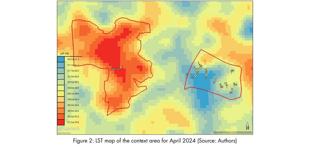
These translations are not only visible but felt with measurable differences in heat accumulation, evident from both satellite-derived land surface temperature (LST) as well as on-site ambient temperature measurements.
Amara Township is a planned urban residential development on Kolshet Road in Upper Thane, Maharashtra. Spread over 50 acres, it features 50 high-rise (30-40 floors) residential towers, landscaped and connected open spaces, tree-lined streets, and structured infrastructure including a multi-level car park (MLCP) and vegetated edge buffers. In contrast, Manorama Nagar is an informal, organically evolved urban neighbourhood, characterised by unregulated plot development, metallic and asbestos rooftops, narrow winding streets, and almost complete lack of vegetation. It can be seen from the LST maps below (Figure 2) that Amara is around 4 degrees cooler than the neighbouring region.
Zoning Right the First time for Heat Mitigation
One of the most evident differences lie in how the two areas were zoned and organised. Amara’s layout is guided by internal zoning regulations/strategy that allocate space for open spaces, green buffers, and structured residential use. In contrast, Manorama Nagar’s land use is densely mixed with commercial and residential functions jostling for space. There are limited dedicated open spaces, no environmental buffers, and very little regard for ecological structure.
From a zoning perspective, this matters immensely. Literature shows that clustering of heat-intensive land uses (e.g., retail markets, warehousing, industrial activities, etc.) without green buffers amplifies local heating (Yu, Kim and Takeuchi 2022; Gabbe, Pierce and Bond 2021). Thanks to strategic zoning, Amara benefits from dedicated vegetation and mixed greenery woven through residential zones, acting as natural cooling systems. The vegetated buffer on the south-eastern edge of the site has been zoned to accommodate dedicated vegetation and a wetland fed by the adjacent drain. These combined, Amara has cool sinks that are integrated throughout the development.
Built Form and Development Controls: More Than Just Population Density
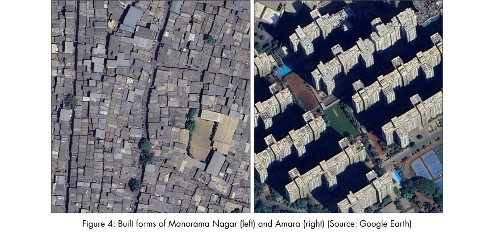
While both areas are "dense” in population terms (Amara can be estimated to house close to 2800 persons per ha (pph) vs. Manorama Nagar’s 2000 pph at the gross residential area), their physical expression of that density is vastly different. Amara’s towers allow for vertical concentration of people, while preserving horizontal openness that provides space for integrating green areas creating shaded pathways and enable wind tunnelling effect. Its built form follows a regulated setback pattern.
Manorama Nagar, on the other hand, demonstrates what happens when 100% ground coverage, irregular heights, and no setbacks dominate. Moreover, along with the narrow spacing, the extended and overhanging balconies substantially reduces the sky view factor (SVF) — a key variable linked to night-time heat retention (Zhou, Huang and Cadenasso 2011) and limits cross ventilation and wind movement within the narrow streets, leading to further heat buildup in the neighbourhood.
Public Realm and Surface Design: Small Decisions, Big Impacts
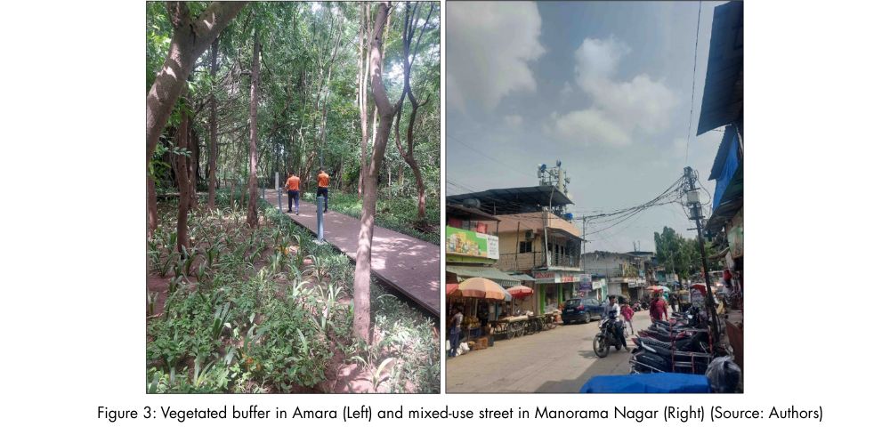
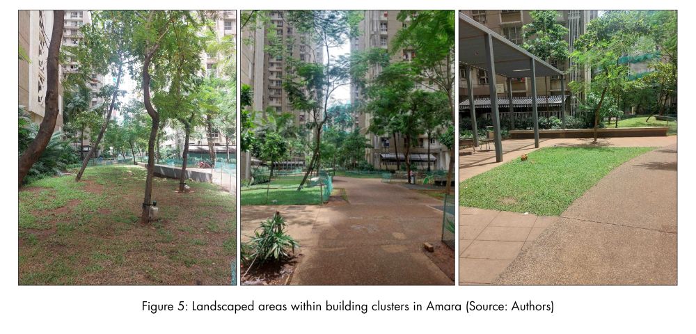
The micro-scale observations in Amara are a strong reminder that plot-level design and surface detailing matter significantly. The ambient temperature inside the building clusters — surrounded by landscaped lawns, shrubs, and shaded by Gulmohar trees – was just 33.5°C, compared to over 36°C in open paved areas in the control site. Shaded walkways, intermitted unpaved areas, tree-lined footpaths, and high-albedo surfaces throughout Amara help reduce heat absorption and re-radiation.
On the other hand, in Manorama Nagar, most internal streets are entirely paved with asphalt or cement. Further, metal roofs reflect heat downward, overhanging balconies block ventilation, and even shaded spots suffer due to lack of airflow.
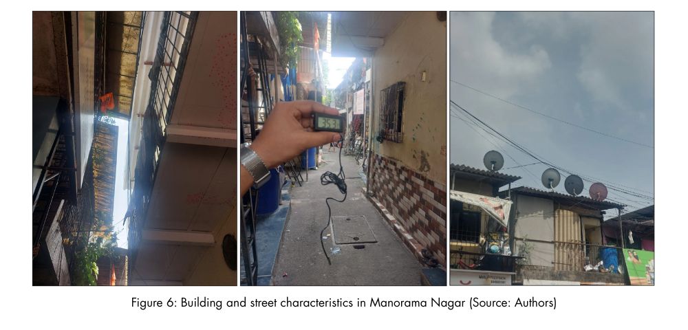
On ground measurements showed that, ambient air temperatures in Manorama Nagar were consistently 2–3°C higher than Amara, peaking at 36.8°C during the same time window at height of 2 meters above ground.
| Aspect | Amara Township (Planned township 1) | Manorama Nagar (Urban Informal) |
|---|---|---|
| LST Range (April 2024, ~10am) | ~30.5°C to 34.5°C | ~34.5°C to 37.8°C |
| Ambient Temperature (2 m above ground, max observed) | 34.9°C | 36.8°C |
| Sky View / Ventilation | High | Extremely Low |
| Vegetation Presence | Significant, maintained | Minimal, fragmented |
| Setbacks and Orientation | Regulated | Irregular or absent |
| Surface Type | Mixed, porous options | Mostly paved, impervious |
| Shading via Trees | Consistent | Absent in inner lanes, minimal in major streets |
Table 1: Comparison across key parameters
Integrated Planning: The Future we want
The Amara township demonstrates planned integration of various services and provisions: strategic vegetation zones, effective storm water management, high albedo surfaces, pedestrian routes that are shaded and direct, and landscape maintenance that is embedded in long-term operation and maintenance. In Manorama Nagar, fragmentation is evident at all levels. The built space is highly unregulated. Observations around the design and structural characteristics of Manorama Nagar, suggest that informal settlements usually do not comply with broader climate resilient strategies which are detailed out in city level action plans. Literature on UHI mitigation consistently flags this issue. Keith, Meerow and Wagner (2023) argue that most cities mention heat only in climate action documents, not in land use or development control regulations (DCRs). Without vertical and horizontal integration across plans, no intervention scale can be effective.
From the ground observations, the Amara–Manorama Nagar comparison is just the tipping point to consider integrated approaches in India’s future cities to be ready for extreme heat. It shows us that urban heat is not inevitable and can be mitigated through design interventions. If planned right, with layout and zoning to incorporate for Nature based Solutions, DCRs to administer for climate appropriate built form and design and informed surface material selection, even high-density settlements can be made thermally comfortable.
Further, to move from awareness to action, the following pathways offer clear directions for embedding heat sensitivity into how we plan, design, and govern urban development.
Pathways for Impact
Urban heat must no longer be treated as an externality. It should be a core planning variable—on par with traffic, sewage, water and power. Municipal budgets must allocate funds for tree planting, reflective coatings, and thermal audits. For new construction, building permits should require minimization of solar exposure and provision for cross-ventilation as essential criteria. City zoning should be guided not just by land prices, but by heat maps also.
In that spirit, the following are actionable pathways for planners, municipal authorities, other line departments and developers. These are feasible to initiate at the city or state level with appropriate institutional support.
- Integrate LST and UHI mapping into statutory development process and master plans.
The current practice followed by urban planners, does not account for assessment for heat vulnerability. It should be addressed at the spatial planning stage by using climate data and simulationsCities should map Urban Heat Vulnerability Zones (UHVZs) using satellite-based LST and NDVI (Normalised Difference Vegetation Index) overlays, layered with built density and demographic exposure. These maps should guide land use allocation, zoning logic (including placing of premise level uses), and open space planning – especially in future draft development plans and local area plans. This can also guide material choices and building design elements as well as retrofitting opportunities in brownfield vulnerable zones. Overall, UHI overlays should be embedded within statutory plans, including Master Plans and Development Plans, and not restricted to climate action plans (such as Heat Action Plan) alone. - Base layout and building approvals from a thermal lens.
Urban planning bodies and applicable layout/building plan approval teams (such as municipal authorities) must be equipped to evaluate site and building proposals through a lens that can enhance thermal comfort. This includes reviewing inter-building spacing, tree placement, roof treatment, and material reflectivity. Even simple logic-based assessments – when incorporated in approval systems – can help prevent future heat entrapment zones. For the same, thermal simulation tools (microclimate modellers such as ENVI-met) can be used to model air and surface temperatures as well as other aspects like wind flow, humidity, etc. as a result of the proposed layout/plot development. This can be coupled with visual checks based on standard practices which can be used to support these decisions. - Promote use of reflective and permeable materials for buildings and public surfaces.
Use of light-coloured, high-Solar Reflectance Index materials for roofs, pavements, and facades can significantly reduce surface temperatures. In Amara, light coloured roofs and permeable paving textures visibly reduced heat, unlike Manorama Nagar’s dark rooftops and continuous paving. City-level regulations should promote cool roof treatments (such as China mosaic, SRI paints, green roofs, etc.) in new buildings, particularly in heat-vulnerable areas, and offer retrofit incentives for existing structures (Refer Agrawal, et al. 2025 for details). Similarly, shaded and permeable paving should be required across footpaths, internal roads, and parking areas to mitigate surface heat buildup. - Provide incentives and fast-track approvals for heat-resilient design.
Heat-sensitive planning – such as layouts that retain open space, enhance sky-view, enhance vegetation, and minimise paved areas – should be encouraged through regulatory benefits tied to specific metrics that represent thermal logic. These may include additional Floor Area Ratio, reduced scrutiny time, or tax rebates for compliance to maximise thermal comfort in urban layouts. - Promote citizen awareness and participation in zoning and plan reviews.
Public involvement is essential to preserving urban cooling assets like trees, wetlands, and open commons. Yet most residents are unaware that zoning plans or layout approvals affect their thermal comfort – or that they can engage with these processes. Awareness-building through workshops, local campaigns, and planning literacy programs can help communities contribute to more heat-resilient neighbourhoods. Community engagement is especially important in heat-prone areas undergoing redevelopment or densification.
Urban heat is not an inevitable cost of development – it is a consequence of how we shape space. As the contrast between Amara and Manorama Nagar shows, even simple design choices can create lasting thermal impact. The opportunity now is to translate this insight into planning norms, building approvals, and community action – before today’s overlooked heat pockets become tomorrow’s unliveable zones.
More critically, city leadership and citizens alike must recognize that thermal comfort is not separate from India’s 2047 Viksit Bharat vision or its 2070 net-zero commitment. They are, in fact, the same mission. Every degree of heat avoided contributes to GDP by improving productivity. Every passive design measure saves electricity, prevents carbon emissions, and reduces risks to life and property—demonstrating a model of growth that is both decoupled from emissions and resilient to climate change.
References
Agrawal, Akanksha, Akhil Singhal, Tarun Garg, and Aun Abdullah. 2025. Cool Roofs, Hot Cities: Insights from Field Evidence and Real-World Application. 25 June. https://www.lodhagroup.com/blogs/sustainability/cool-roof-benefits-government-policies-challenges.
APA. 2021. Planning for Urban Heat Resilience. PAS Report No. 600. Chicago: American Planning Association.
ARSET. 2022. “Satellite Remote Sensing for Measuring Urban Heat Islands and Constructing Heat Vulnerability Indices.” NASA Applied Remote Sensing Training Program (ARSET). https://appliedsciences.nasa.gov/get-involved/training/english/arset-satellite-remote-sensing-measuring-urban-heat-islands-and.
Gabbe, Christopher J., Gregory Pierce, and Alexander Bond. 2021. “Why and How Do Cities Plan for Extreme Heat?” Journal of Planning Education and Research. https://doi.org/10.1177/0739456X211053654.
Guldmann, Jean-Michel, and Zhonghua Zeng. 2014. “Modeling the Urban Heat Island Effect Using Land Use and Socioeconomic Data.” Environment and Planning B: Planning and Design 41 (4): 692–710.
Islam, Sahidul, Anandakumar Karipot, Rohini Bhawar, Palash Sinha, Sumita Kedia, and Manoj Khare. 2024. “Urban heat island efect in India: a review of current status, impact and mitigation strategies.” Discover Cities. https://doi.org/10.1007/s44327-024-00033-3.
Keith, Lauren, Sara Meerow, and Travis Wagner. 2023. “Evaluating Urban Heat Mitigation across Networks of Plans.” Urban Climate 48. https://doi.org/10.1016/j.uclim.2023.101743.
Kotharkar, Ruchi, Nitin Surawar, and Kanchan Raut. 2020. “Land Surface Temperature as a Tool to Assess Heat Vulnerability: A Case Study of Nagpur, India.” Urban Climate 34. https://doi.org/10.1016/j.uclim.2020.100701.
Lodha and RMI India Foundation. 2023. “Gateway to India’s Dymaxion.” www.lodhagroup.in/netzerourbanaccelerator/rmi-lodhasustainability-conclave.
Pearce, Fred. 2018. Urban Heat: Can White Roofs Help Cool World’s Warming Cities? 7 March. https://e360.yale.edu/features/urban-heat-can-white-roofs-help-cool-the-worlds-warming-cities#:~:text=Summers%20in%20the%20city%20can,to%20maintain%20our%20cool%20grows.
Shrivastava, Mrinal, Akhil Singhal, Tarun Garg, and Aun Abdullah. 2025. Insight Brief - Re-Thinking Urban Heat Islands: High Density yet Cooler Urban Development. 28 April. https://www.lodhagroup.com/blogs/sustainability/urban-heat-islands-high-density-cooler-urban-development.
Stone, Brian. 2005. “Urban Heat Island Mitigation: Strategies for Cities.” Journal of the American Planning Association 71 (1): 13-25. https://doi.org/10.1080/01944360508976402.
TERI. 2017. Final Report on Urban Planning Characteristics to Mitigate Climate Change in Context of Urban Heat Island Effect. New Delhi: The Energy and Resources Institute. https://www.teriin.org/sites/default/files/2018-03/urba-heat-island-effect-report.pdf
Yadav, Anita, and Jaswant Singh. 2024. “A Study on Urban Heat Island (UHI): Challenges and Opportunities for Mitigation.” Current World Environment 19 (1). https://cwejournal.org/vol1no1/pa-study-on-urban-heat-island-uhi-challenges-and-opportunities-for-mitigationp#:~:text=Urban%20Heat%20Island%20,the%20effects%20of%20UHI%20in.
Yu, Chuan, Kazuaki Kim, and Kenta Takeuchi. 2022. “Plan Evaluation for Heat Resilience: Tokyo Case Study.” Urban Climate 41. https://doi.org/10.1016/j.uclim.2021.101070.
Zhou, Weiqi, Weifeng Huang, and Mary L. Cadenasso. 2011. “Does Spatial Configuration Matter? Understanding the Effects of Land Use Patterns on Land Surface Temperature in Urban Landscapes.” Landscape and Urban Planning 102 (1): 54-63. https://doi.org/10.10.
You may also like
 Lodha Foundation & Sustainability
 Lodha Foundation & Sustainability
 Lodha Foundation & Sustainability
Recent Blogs
 Lifestyle & Culture
 Lifestyle & Culture
 Lifestyle & Culture
